Unveiling Machaerus: Exploring History and Mystery Through the Machaerus Map
Machaerus, a name steeped in history and mystery, stands as a testament to the ancient landscapes of the Holy Land. Nestled within the rugged terrain east of the Dead Sea, Machaerus emerges from the pages of antiquity as a formidable fortress with a storied past. To understand the significance of this ancient site, we delve into the depths of historical accounts and archaeological findings, guided by the contours of a Machaerus map.
The fortress of Machaerus holds a pivotal place in the tumultuous events of the 1st century. Built by the Hasmonean ruler Alexander Jannaeus around 90 BCE, Machaerus commanded a strategic position overlooking the Dead Sea, serving as a sentinel against invasions from the east. Its rugged cliffs and imposing walls rendered it virtually impregnable, making it a coveted prize for any power seeking to control the region.
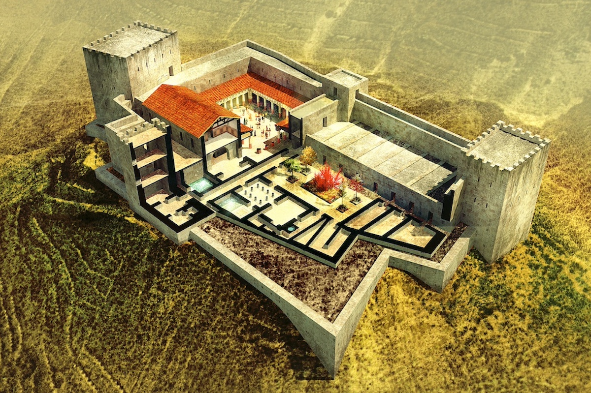
However, it was during the reign of Herod the Great, the Roman-appointed king of Judea, that Machaerus rose to prominence. Herod, known for his ambitious building projects and ruthless tactics, recognized the strategic value of Machaerus and undertook extensive renovations, transforming it into a formidable fortress-palace complex. The Machaerus map from this era would reveal a sprawling compound, complete with barracks, storerooms, and luxurious accommodations fit for a king.
Despite its strategic importance, Machaerus is perhaps best known for its association with one of the most tragic episodes in the New Testament—the imprisonment and execution of John the Baptist. According to the Gospel accounts, Herod Antipas, son of Herod the Great, ordered the arrest of John the Baptist and imprisoned him in Machaerus after the prophet denounced his marriage to Herodias. The details of John’s martyrdom at the hands of Herod are etched into the annals of Christian history, immortalized in art, literature, and religious tradition.
The Machaerus map serves as a guide through the labyrinthine corridors of history, offering insights into the fortress’s layout and strategic significance. From its commanding views of the Dead Sea to its fortified walls and defensive towers, every feature speaks to the military prowess and architectural ingenuity of its builders.
Archaeological excavations at the site have unearthed a treasure trove of artifacts, shedding light on daily life within the fortress and the tumultuous events that unfolded there. From pottery shards and coins to inscriptions and architectural remnants, these discoveries provide tangible connections to the past, allowing us to reconstruct the story of Machaerus brick by brick.
Beyond its role in biblical narratives, Machaerus embodies the resilience and tenacity of the human spirit in the face of adversity. Its stark silhouette against the desert sky serves as a poignant reminder of the fleeting nature of power and the enduring legacy of faith and sacrifice.
In conclusion, the Machaerus map offers a window into a bygone era of intrigue, ambition, and faith. From its origins as a Hasmonean stronghold to its pivotal role in biblical history, Machaerus stands as a silent witness to the triumphs and tragedies of the human experience. As we trace the contours of its walls and walk in the footsteps of those who once trod its halls, we are reminded of the timeless lessons that echo through the corridors of history.